Eric Edmondson posted on the Great North Airlines page this week about two platforms the airline now runs for emergency response in Canada. ForIT had a hand in both, so we waited for Eric to go first. This is the longer version: what the two platforms do, and why we think the approach matters for other operators.
Two ends of the same problem
The first platform is about intelligence. It watches wildfires and floods across the country in real time and predicts where aircraft will be needed, for how long, and what conditions crews will meet when they get there. It ran through the whole 2026 wildfire season and is being adapted for flood season now, with more weather and satellite data feeding it every month.
The second is Fleet Call. Approved agencies, municipal, provincial, territorial and federal, including disaster relief, military and law enforcement, sign in and see live aircraft status, current base and estimated deployment time, and can go from availability to a live commitment with the operations team.
They sit at opposite ends of a deployment. One says where the need is building. The other lets the agency that has the need act on it.
What the intelligence side actually does
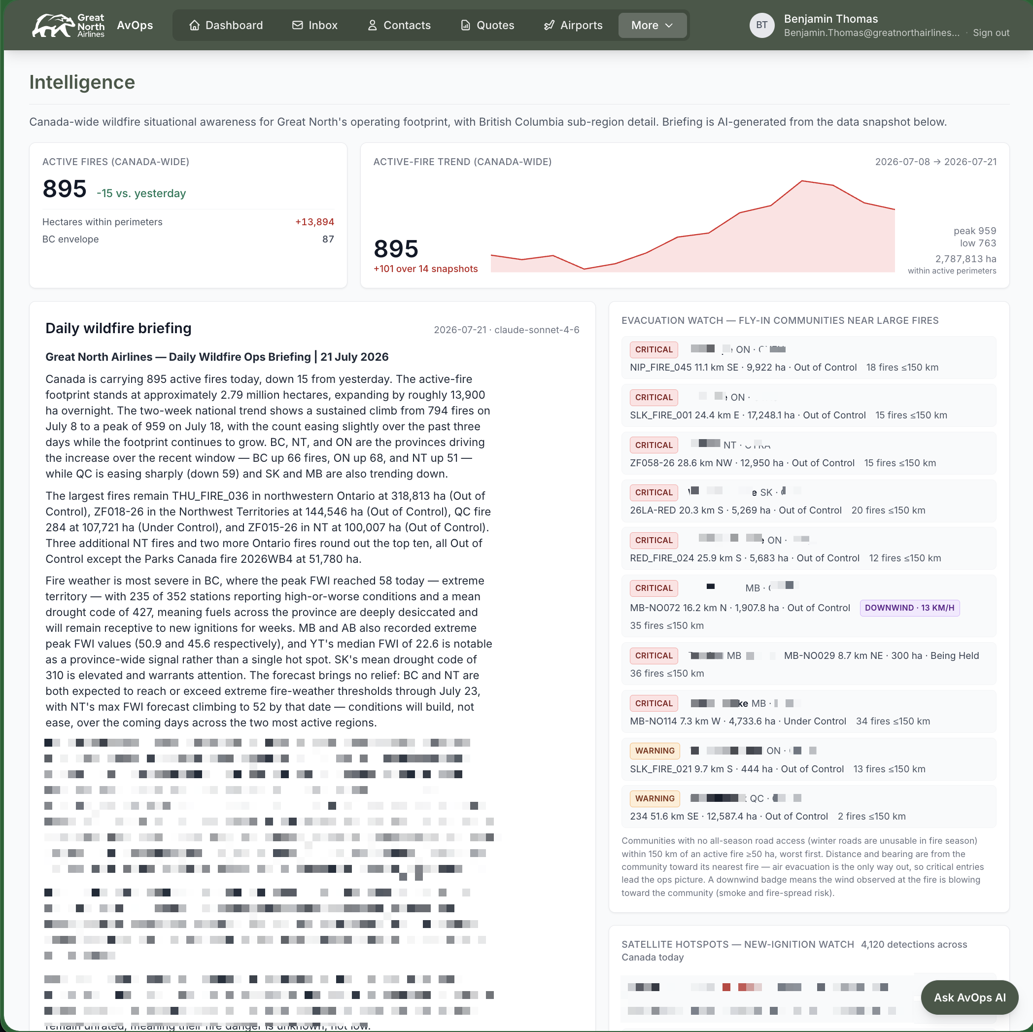
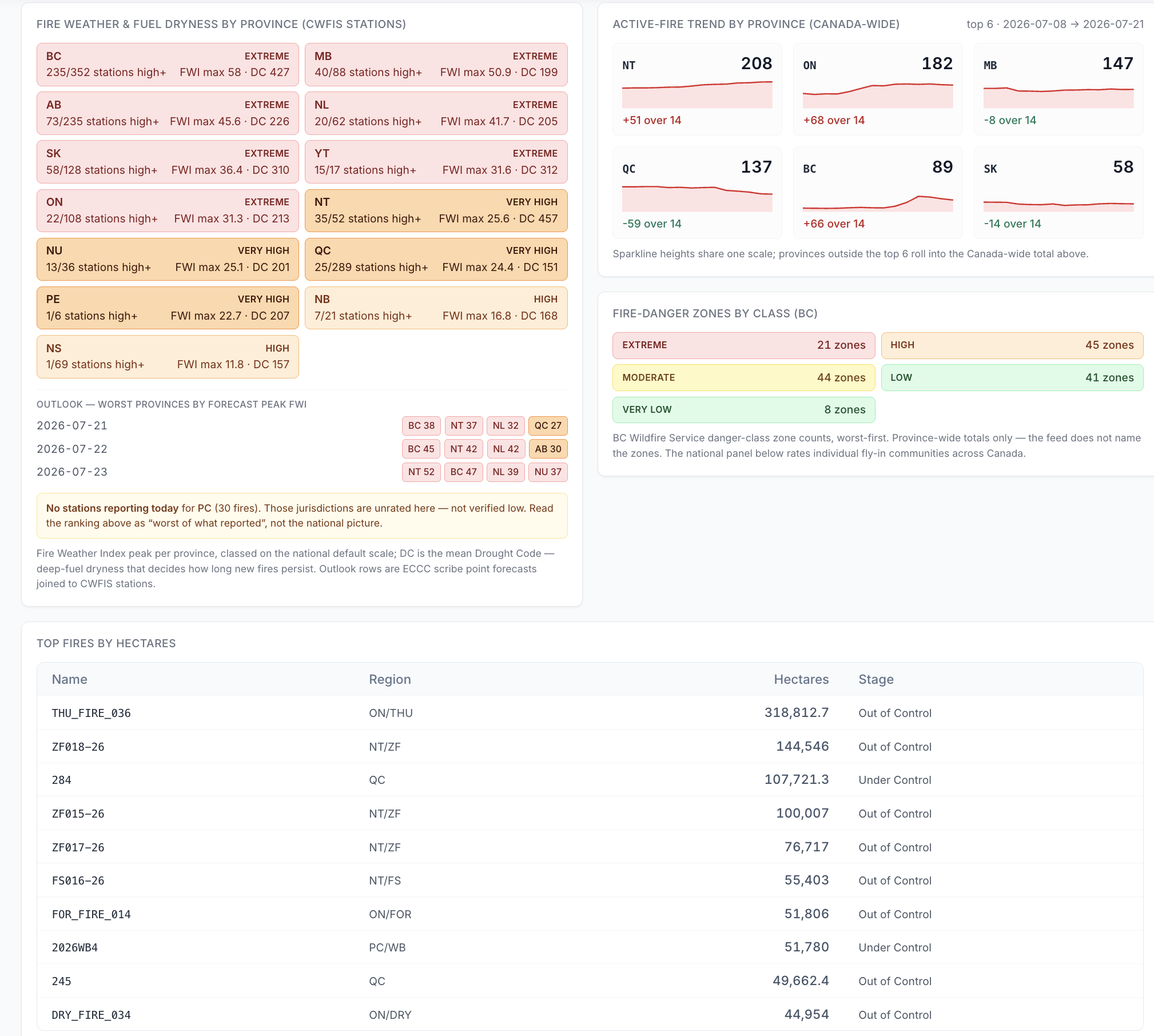
Everything starts with what federal, provincial and local agencies already publish, along with what the communities themselves report. The platform gathers that into one portal. On top of it, Great North adds satellite hotspot detection, a fire-weather and fuel-dryness outlook by province, and its own analysis. What the planning team sees:
- A daily briefing, written from that day's data snapshot.
- Activity trends across the country, and which situations are moving toward something more serious.
- An evacuation watch that ranks the communities reachable only by air by how close they sit to the most serious events, worst first.
- An early signal from satellite detection that surfaces new activity before it has a name or a size.
- A forward-looking weather layer, refined in real time.
That lets Great North arrange the practical things before the call comes: crew accommodation, maintenance support, crew transportation and local travel, with a read on how long the deployment will likely run.
What other operators should take from it
None of that data was secret. It was public the whole time. The gap was that nobody had wired it into the airline's own systems so the planning team could see it where they already work.
That is a build, not a purchase. The expensive parts used to be the plumbing: pulling a dozen inconsistent public feeds, reconciling them, and turning them into something a person can read before the morning call. Those parts have become cheap enough to justify for a regional operator. What is left is knowing the operation well enough to decide what belongs on the screen, and that knowledge already lives with the operator, not with a vendor.
Where it goes next
Wildfire now, flood next, and built to plug into other regions' feeds when the aircraft travel during Canada's quieter months. Great North has also said it is no longer building alone: collaboration with clients, agencies and academia is shaping what comes next.
Both of Great North's writeups are on its site: A predictive tool for natural disasters across Canada and Fleet Call. Eric's post is on the Great North Airlines page.
If you run an operation with the same shape of problem, public data and no operator view of it, that is a conversation we are glad to have.
Benjamin Thomas
ForIT Team